 |
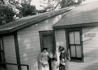
| Tudhope Park Cabins, 1957 |
Tudhope Park in Orillia has been the center of outdoor activity here for more years than I can remember. The property was gifted to Orillia by the Tudhopes, though at the current time, I don't have a date for this I hope to eventually be able to post up the details of the park's history (after a trip to the new library, when it's completed). I do know that a large portion of the property was in use as a campground from at least the 1950s (maybe earlier). Back then, most of the campers used tents, but there were cabins along the shoreline facing Moose Beach too. These were small wood cabins that vacationers could rent for their holiday.
My husband's family vacationed at Tudhope Park from the late 1950s, starting out with rented cabin space and moving on to rent a "waterfront" lot on the other side of the point for their own camping trailer. Lots could be had for the duration of the summer months, and campers holding waterfront lots built all manner of things from decks out over the water to docks for their motorboats.
 |
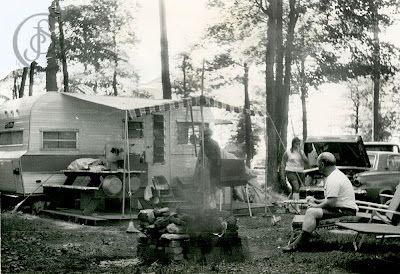
| Campgrounds at Tudhope Park, 1969 |
My mother's sister and brother-in-law had a trailer at Tudhope Park too, even though at that point in time they lived in Orillia. Back then, camping was "the" outdoor thing to do, and was popular with families because costs were low and upkeep was minimal.
My parents bought their first trailer in 1969 and they had it delivered to Tudhope Park, to a rented space just behind my Aunt and Uncle's trailer - our shiny new "travel trailer" look odd next to all the older rounded-shell trailers at that time. My husband's family had their trailer a lot-space away from my Uncle's, and to the front and right of ours.
In 1969, the campgrounds were always full and the beehive of activity for the younger set was the canteen, and the camp store. Both of these were long ago closed down (the canteen first, then the store). The building most of us called the canteen was really just a very large shed-type building connected to the store with a covered walkway. It had a concrete floor and mostly was just a big empty hall. It was a place to congregate when it was raining, and sometimes there were dances. The store carried the necessities, as well things like gum and candy.
 |
| Tudhope Park, 1969 |
During the time we camped at Tudhope (only for that one year) there were centralized washrooms and showers, a laundryroom, the changerooms washrooms on the beach (Moose Beach), and some of the cabins were still in use.
 |
| Tudhope Campground, 1957 |
When my own kids were young, we took them into Tudhope Park to camp in a tent trailer, even though we lived only a few blocks from the park. At our house, the heat of the summer could be unbearable at times, but at Tudhope Park the breeze off the lake was almost always refreshing, and as a working mom, camping meant less housework and cleaning. That was during the 1980s.
As near as we can figure, the camping ceased in the late 1980s or early 1990s (need to do more research here). I miss those campgrounds a great deal, and the open parkland is somehow, not as appealing though I suspect part of that is simply the visual emptiness where the memories in my mind are looking for more than what's currently there, and sometimes, looking for what's less than there. Like the curling rink. The Barnsfield Point was built out here at the edge of the park. Back when it was built, I was not a happy camper. Sure, we needed a new curling (badly, or so the curlers told me) rink, but did it have to be at the park? pffft. And, like the monstrous new playground they built right on the beach (dumbest idea - ruin the beach with a...water park?) instead of in the parkland area? I dunno, but sometimes progress isn't so progressive. I'm not overly thrilled, either, by the large and very prominent hydro poles running right through the middle of this new water park. Whose idea was that? Did anyone give a thought to chance here? Bad storm, high winds and bang...downed power lines over a waterpark. Nice. While safety is the first thought that comes to mind, the visual impact of this ugliness is almost overwhelming. It isn't a pretty sight.
 |
| The new waterpark on Moose Beach (Tudhope Park, Orillia) with hydro poles. |
"Back when" all the trails through the park area were basically footpaths created by the many feet of walking people, and the "roadways" were dirt. Sort of what you expect in a park...not a lot of pavement like we've got now. I don't like it, but I do understand the need to make parks accessible to everyone, including those in wheelchairs or those that need smooth, solid ground beneath their feet, like people using walkers. So at the present time, Tudhope Park is accessible to pretty much everyone, and contains a lot of open (and somewhat useless) space, with nice paved pathways and trails, and not much else. There are benches along the paths for those who simply want to sit and ponder the day, or those who need to rest along the way. A few picnic tables are scattered about, but not often seen in use. There is a large baseball diamond at the front portion of the park, adjacent to the curling club and nearby the water's edge is a large sandpit with netting for volleyball or badminton.
There is a gallery of recent imagery from Tudhope Park that covers most of the areas of the park, including the water park on the beach. You can see this gallery here (this should open in a new window):
Tudhope Park (May 2011) Other images from Tudhope Park can be seen below.
SCENES FROM THE PARK
![]() |
| A family vacation, c. 1957 at Tudhope Park, Orillia |
 |
| Camping in Tudhope Park, 1969 |
 |
| An early morning walk at Moose Beach (Tudhope Park), Orillia (2004) |
 |
| An artistic rendering of the lower section of Tudhope Park, Orillia (end of summer) |
 |
| Park of the paved walkway on the point, Tudhope Park (summer) |
 |
| A long view of the point area at Tudhope Park, Orillia |
 |
| A snow-covered bench in winter, Tudhope Park, Orillia |
|
 |
| A view of Tudhope Park during winter. |
 |
| Old buildings in Tudhope Park refurbished for the Orillia Rowing Club. |
View Tudhope Park, Orillia in a larger map


